Winter storm systems continue to slam commonwealth
Published 10:00 pm Saturday, February 13, 2021

|
Getting your Trinity Audio player ready...
|
While Kentucky continues to dig out from the latest winter storm, the National Weather Service is already looking ahead to the next system, expected to begin affecting the state Sunday evening.
Winter storm watches were issued for all of Kentucky due to a combination of snow, sleet, and freezing rain that is in the forecast.
Trending
During a Saturday afternoon conference call, John Gordon, who heads the National Weather Service office in Louisville, said the system will be moving into Kentucky from the southwest.
“This caused problems in Portland, Oregon,” he said. “It’s diving into the Rocky Mountains, then into Texas, Oklahoma, and Arkansas. It’s going to really slam the mid-south and go all the way up the East Coast.”
Two waves will impact the region and bring rounds of wintry weather with them. The first will arrive Sunday night and persist into Monday morning, and the second will be right on its heels and arrive Monday afternoon and continue into early Tuesday morning.
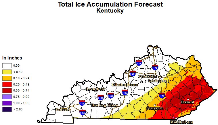
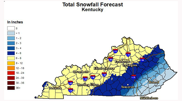
He said all forms of winter weather are on the table. “We’re expecting heavy snow, sleet, freezing rain all across Kentucky, from late Sunday through Tuesday. We’re going to have a distinct freezing rain event across the eastern part of the state, a distinct sleet event to the west of that, and a distinct snow part of the forecast, further to the west.”
The heaviest snow is currently forecast west of a line from Bowling Green to Lexington and on to South Shore in northeastern Kentucky, where six to eight inches of snow is possible during that time.
South and east of that line, there will be less snowfall, but more ice, where accumulations could be up to ¾ inch of ice. See the accompanying maps for details.
Trending
Gordon notes that they look at a lot of data, so things could change over the next 24 hours. “We look at everything from UPS planes (which report weather conditions during flight), to short and long-range models. We try to scan the layers of the atmosphere to see what’s going to happen.”
He says the latest several model runs have trended to move the storm further east, so no warnings will be issued until the Sunday morning forecasts are issued.
This means it’s important if you are planning on going out on Sunday, to stay abreast of the latest local forecast.
Gordon adds whatever we get from this storm will have a big effect on the next system, which is expected to affect Kentucky on Wednesday and Thursday.